The Application of WebGIS in Urban Planning

The Application of WebGIS in Urban Planning: A Step Toward Smart Decision-Making and Sustainable Urban Management In recent decades, with the expansion of modern information technologies, the need for interactive and intelligent systems in urban planning and management has become increasingly evident. Among these innovations, WebGIS—Web-based Geographic Information Systems—has emerged as a transformative tool in […]
(AQI)Air Quality Data
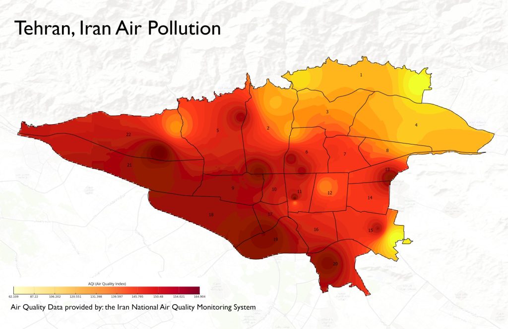
With the increasing air pollution caused by temperature inversions in recent days, I created a resource to make air quality data more accessible. This interactive map allows users to explore and download Realtime AQI data.🔹 The map is built using the API from Iran’s National Air Quality Monitoring System.🔹 You can easily download the data […]
Spatial Statistics in Urban Planning with ArcGIS Pro

I’m thrilled to announce the publication of a specialized Persian book in the field of Urban Planning and Spatial Statistics, a result of more than two years of collaborative research and writing with Dr. Toktam Hanaei and Engineer Masoud Ebadi. This comprehensive resource integrates theoretical foundations with 19 practical exercises, making it a valuable tool […]
15Min Cities | Webgis

Explore the “15-minute city” concept and customize your experience by changing your mode of Travel from Walking to Riding or Driving. Discover key services within 10, 15, and 30 minutes from your chosen location, and join us in building more accessible, sustainable cities! 🌍🚶♂️🚴♀️🚗 Online access to WebGIS: mohammadvahidi.com/15min-city/
The Historical Maps of Mashhad(Interactive)

The Historical Maps of Mashhad | An Interactive Online Version for Historical Urban Analysis Historical city maps are among the most valuable tools for urban planning, urban regeneration, and the study of spatial development. Researchers, students, and those interested in urban history often seek digital versions of old city maps to explore how urban structures […]